

Everything Pathr can do
The modern boating app, feature by feature: charts, smart routing, live weather, and the tools that keep you safe on the water.
Built for real navigation
The core of the app: official charts, a route that respects your draft, offline coverage, and a watchful anchor.
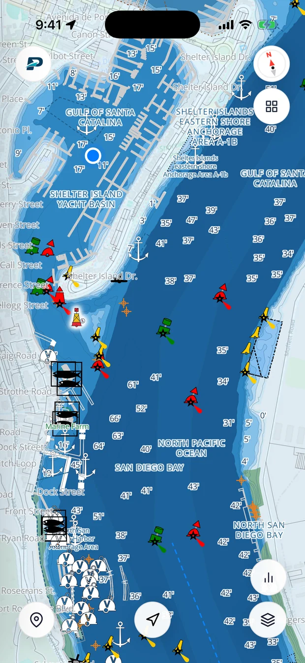
Official NOAA charts
A full vector nautical chart with your live GPS position as a blue dot. Everything a paper chart shows, updated and in your pocket.
- Depth-shaded water and soundings in feet
- Buoys, beacons and anchorages
- Rocks, wrecks and obstructions marked
- Tap any mark for its details

Smart auto-routing
PremiumPick a destination and Pathr plots a depth-aware route that follows navigable water and steers around the shallows, then rates it.
- Follows the channel, not a straight line
- Distance, ETA and a Route Safety score
- Live guidance with Start Navigation

Charts that work offline
5 GB with PremiumSignal disappears offshore. Download chart regions to your phone so navigation keeps working with no connection: 200 MB of charts free, 5 GB with Premium.

Anchor Watch
Premium historyDrop anchor, set a watch radius, and Pathr sounds a drag alarm if your boat swings outside it. The alarm is free; with Premium, every watch is saved to your history.
Know the weather before you go
Live conditions painted right on the chart, plus the forecast for the days ahead.

Live weather overlays
Premium layersSwitch on wind and waves as animated layers over the chart, each with its own legend. Radar, temperature, AIS vessel traffic and the seabed layer come with Premium.
- Animated wind and wave fields
- Rain radar (Premium)
- AIS traffic and seabed layers (Premium)

Full marine forecast
Current wind and waves, an hourly outlook for the next 24 hours, and a 7-day forecast with temperature, wind, and wave height.
And a lot more
Every other tool in the app, from planning to logging to sailing with friends.

Routes built for your boat
Set your vessel's draft and beam. Automatic routes (Premium) are planned around charted depths for your boat's draft and given a Route Safety score. Check every route against the chart and the conditions before you go.

Customize the chart
Premium presetsFull control over depth areas, contours, and soundings on the Day chart. Night and High-Contrast presets and automatic night mode come with Premium.

Save your spots
Long-press the map to drop a waypoint (a marina, anchorage, fishing hole, or dive spot), then find them all, filtered by type.

Community reports
Premium to viewFile on-the-water reports for free: hazards, weather, harbor and dock notes, boat launches, and wrecks. Seeing what other boaters report is Premium.

Every trip, logged
Premium to viewPathr automatically records each outing with its route, distance, average and max speed, and duration. Looking back through your Sailing History is Premium.

Trip checklists
Build packing and prep lists so nothing important gets left at the dock before you cast off.

Sail with friends
Add friends with a code or QR and optionally share your location, so your crew can see where you are and follow each other's miles.

Earn badges
Your profile tracks badges and points as you rack up trips and milestones, a fun way to mark your progress as a sailor.

Instrument dashboard
A big, glanceable panel: speed, heading, and, when navigating, ETA and distance to destination. Easy to read from the helm.

News & updates
Release notes and field reports from the team building Pathr, so you always know what's new.

Free & Premium
Pathr is free. Premium adds automatic route planning, radar, AIS and trip history, and is free for your first two months.
Premium features are free for your first two months.

